

About Gillfield Wood
Gillfield Wood is around 20 - 30 acres of mainly deciduous mixed woodland, south of the parish of Totley. Originally a Derbyshire village, Totley is now a suburb at the south-western edge of the city of Sheffield. The western end of the wood stretches to the A621 Baslow Road near to the boundary of the Peak District National Park below high moorland known as Totley Moss.
A long sinuous crescent in shape, Gillfield, in common with many other ancient woods, lies on a parish boundary. The Totley Brook which flows through most of it divides Totley from the Derbyshire parish of Holmesfield.
The wood has one main footpath along its length and is crossed by three other main footpaths – to the North leading to old Totley village and Totley Hall; to the south to the Holmesfield settlements of Woodthorpe and its Hall, to the historic Fanshawe Gate Hall and to the ancient farmstead of Storth House and Storth Lodge (previously the home of ramblers’ campaigner GHB Ward).
History of Gillfield Wood
An ancient wood is one which is evidenced as older than 1600. Gillfield is an ancient wood - we know this through documentary and archaeological evidence and even through the particular species growing in the wood.

Though we have no proof, the wood mentioned in the Domesday Book may be Gillfield.
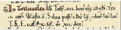
In Totingle, Tolf had IV bovates of land hidable, land for one plough. It is waste. Wood pasturable, 1 mile in length and half a mile in breadth. TRE val X shillings, now XII pence. (Domesday Book 1086).
This wood was ‘pasturable’ – ie used for grazing animals such as pigs who would eat the acorns.
However, the first proper documentation of Gillfield is found in Cameron’s Placenames of Derbyshire which refers to a 1561 survey in which Gillfield is ‘a springe wood called Jyll felde.” A ‘spring wood’ means that it was coppiced, so certainly by this time animals would have been kept out.
An extract from manuscript diary of William Dickenson, Bailiff of Hallamshire tells us: Woode vewed and marked at Totteley the 17th of December 1574. This is a stocktake of the wood and refers to what are probably compartments –The Carre, Fraunces Field, Husters andLong Springe. Local names of prominent landowners are also in evidence –Newebolte (probably Newbould), Barker and Yellot (or Elliot).
Even without this documentary evidence, Gillfield’s shape ‘with well marked peninsulas and bays like a rocky coast as if giant bites taken out’ tends to confirm that it is indeed an ancient coppice wood – ‘the result of unplanned piecemeal clearing process which in the medieval period was known as assarting and resulted in creation of small irregular fields.’ (quotes from Professor Mel Jones).
An aerial photograph of the wood shows its typical ancient woodland shape. The hedgerows show the ‘ghost wood’ and seem to confirm that the wood was once much bigger. Some of the original wood may even have been cleared in pre Norman times – many of the nearby field names are Old English or Norse in derivation and refer to cleared woodland eg Stubbins, Storth Lees, Dunniholme. Totley’s name itself probably also means ‘woodland clearing belonging to Tota.’

A hedgerow survey in progress seems to suggest that hedges in fields around the wood are at least medieval - showing a clearing for agriculture by this time. A recent flora survey tends to confirm that Gillfield is an ancient wood and may give us further clues as the management of the wood in the past. Many of its springtime woodland flora are ‘ancient woodland indicators’ such as wood anemone, bluebells, yellow archangel and various ferns.
Between the last quarter of the sixteenth century and the middle of the eighteenth century the wood was coppiced for whitecoal making. Whitecoal was effectively wood with all the water driven out and was used for smelting lead from Derbyshire in water powered mills (there were at least two leadmills in Totley). Bob Warburton in his 1970’s survey of the wood discovered over 20 small depressions and the group has discovered more. We now know that these were whitecoal kilns or Q pits. These and other archaeological remains are to be surveyed and plotted by the group.
The ownership of the wood has yet to be properly researched though we know from the 1574 inventory that the owner at that time was the Earl of Shrewsbury (of Mary Queen of Scots fame). In the late 19th century it was owned by the D’Ewes Coke family and in the early 20th century by the Milners of Totley Hall. The wood was cut down during the Second World War and soon after sold to the Estates Department of Sheffield City Council. In the 1960’s the Estates Department replanted it, mostly with American Oak and larch. The wood has had minimal management until the Friends Group was formed in 2011 to work in partnership with the Parks and Countryside Department of the City Council.

Video Tour of Gillfield Woods
Introduction http://www.youtube.com/watch?v=WMOCmo6puqE
Swimming Pool http://www.youtube.com/watch?v=Vcq_JdUeLvE
Q-Pits http://www.youtube.com/watch?v=flLvioKp4S0
Shooting Cabin http://www.youtube.com/watch?v=Wfqi_1-9s2c